OpenStreetMap es maravilloso

OpenStreetMap es maravilloso pic.twitter.com/nbQ9BLS4f6
— Alfonso @skotperez (@skotperez) October 8, 2021

OpenStreetMap es maravilloso pic.twitter.com/nbQ9BLS4f6
— Alfonso @skotperez (@skotperez) October 8, 2021
We are allowed to map certain facts from reference imagery in news articles etc.. -though this technically depends on where you are from-. You have to
be fairly certain of the position of each object. They can be a few meters off, but you shouldn’t haphazardly map them.
select sources which are reliable and mention them in your changeset sources or alternatively using the source and source:date tags.
make sure you’re using the right imagery and (if any) offset. This can be adjusted in the editor’s layer menu (in iD, this is located in the right sidebar).
be careful if/when touching existing objects. (You may want to contact the local community, if there is one, to discuss whether they want to map the event to begin with); This may change/remove objects on the map 1) ways which are used for routing 2) areas, such as buildings, or POIs which may be of interest for humanitarian aid.
You will have to use the proper Lifecycle tags (in combination with area=yes where needed).
be sure you know how to map with multipolygons where needed.
as always, look on the wiki for tags and ask the community if you need help mapping.
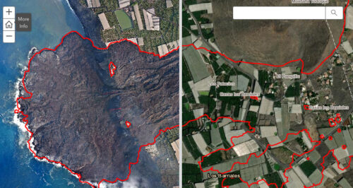
Primer mapa del impacto de la lava del volcán en La Palma a partir de imágenes satelitales. Fuente: Copernicus – Comisión Europea