GeoPandas. Reading and writing files

GeoPandas can read almost any vector-based spatial data format including ESRI shapefile, GeoJSON files and more using the geopandas.read_file() command

GeoPandas can read almost any vector-based spatial data format including ESRI shapefile, GeoJSON files and more using the geopandas.read_file() command
This post walks through the steps I followed to build a web-based map using Python, Folium, and GeoPandas — from handling shapefiles to adding custom tooltips, interactive toggles, and responsive feedback using JavaScript libraries like AlertifyJS.
…the geodatasets package. This new package, separated from the main GeoPandas library, focuses on access to and management of spatial datasets. We’ll walk you through installing geodatasets and demonstrate how it complements GeoPandas in handling geospatial information.
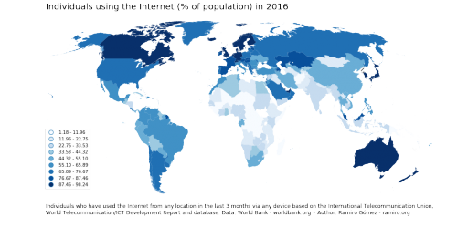
There are different ways of creating choropleth maps in Python. In a previous notebook, I showed how you can use the Basemap library to accomplish this. More than 2 years have passed since publication and the available tools have evolved a lot. In this notebook I use the GeoPandas library to create a choropleth map. As you’ll see the code is more concise and easier to follow along.