GeoPandas. Reading and writing files

GeoPandas can read almost any vector-based spatial data format including ESRI shapefile, GeoJSON files and more using the geopandas.read_file() command

GeoPandas can read almost any vector-based spatial data format including ESRI shapefile, GeoJSON files and more using the geopandas.read_file() command
This post walks through the steps I followed to build a web-based map using Python, Folium, and GeoPandas — from handling shapefiles to adding custom tooltips, interactive toggles, and responsive feedback using JavaScript libraries like AlertifyJS.
In this tutorial, we’ll explore how to create and visualize GeoJSON data, a popular open-source format for representing geographic data, using geojson.io and Folium in Python.
I usually handle GIS data in GIS software off course. In this blog post, I’d like to try visualize GIS data with p5.js!
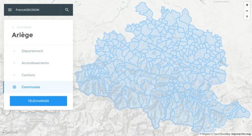
Le projet Github france-geojson propose au format GeoJSON les cartes des régions, départements, arrondissements, cantons et communes de France (métropole et départements d’outre-mer) à partir des données publiées par l’IGN et l’INSEE.
Ce site permet de rechercher, visualiser et télécharger individuellement chacun de ces fichiers dans un format optimisé. Pour plus de détails ou pour accèder à la version non optimisée des tracés, cliquez sur le bouton ci-dessous.