
The Detroit Geographic Expedition and Institute: A Case Study in Civic Mapping

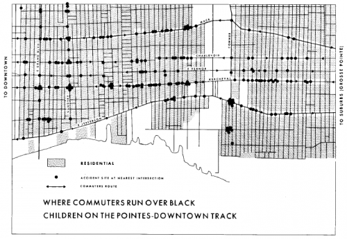
the most important part of the Field Notes III for Gwendolyn Warren was the research on children’s deaths caused by automobile accidents. She described how a great deal of commuter traffic from the affluent white suburbs to the Downtown area passes through the Black community and poses significant threat to the children. On one single corner alone there were six children killed in six months. Just gathering the data that the community already knew to be true posed a difficult problem. No one was keeping detailed records of these deaths, nor making them publicly available. “Even in the information which the police keep, we couldn’t get that information. We had to use political people in order to use them as a means of getting information from the police department in order to find out exactly what time, where, how and who killed that child. (Warren, p. 12)”
This research culminated in the map entitled, provocatively, “Where Commuters Run Over Black Children on the Pointes-Downtown Track”.
As Warren points out in her analysis, the fact that the map establishes a pattern proves that the children’s deaths are not isolated incidents but rather indicative that the spatial and racial injustice of the city leads to the bodily harm of the most vulnerable members of its lower classes. Denis Wood, a geography scholar who has written about the map in various publications, is definitive, “Any Detroiter would have known that these commuters were white and on their way between work downtown and home in the exclusive Pointes communities to the east. That is, this is a map of where white people, as they rush to and from work, run over black children. That is, it is a map of where white adults kill black kids. It is a map of racist infanticide, a racial child-murder map. (Maps and Protest article)”